
Los Alamos Archives – One for the Money Two for the Road
Featured 
Bandelier National Monument has been on our to-do list for years, so we were thrilled to finally make the trip. We enjoyed everything about Bandelier, from the scenic drive through the scenic Jemez Mountains, to the history, and the ancient dwellings in Frijoles Canyon. The tour starts here, and we hope you enjoy it too! 
Where is it?
Bandelier National Monument is about 12 miles south of Los Alamos, New Mexico, a 17-minute drive via State Road 501 and State Road 4. There are a couple of scenic overlooks along the roads, so allow time to stop – the views are worth it. The park’s physical address is 15 Entrance RD, Los Alamos, however we do not recommend using GPS for directions to the park as we found the internet service to be very sporadic.
 On the road to Bandelier.
Features of the park include:
- Frijoles Canyon visitor center/park film/museum
- Bookstore/gift shop
- Picnic tables
- Bandelier CCC Historic District featuring historic park buildings.
- Periodic ranger talks
- Periodic ranger guided tours, walks, and hikes.
- Stargazing and periodic night sky programs
- 70 miles of hiking trails
- One family campground, one group campground, backcountry camping with permit
- Winter cross country skiing trails
Note: The only access to Bandelier during the summer months is via White Rock Visitor Center, 115 State Road 4, White Rock, New Mexico, where visitors can leave their vehicles and take a 20-minute shuttle ride to the park. Shuttles run every 20-30 minutes. Click here for the park’s website.
 Frijoles Canyon overlook with the cloud shrouded Jemez Mountains in the background.
Bandelier CCC Historic District
President Woodrow Wilson declared Bandelier a national monument in 1916. Then, as with many other national park units, the Civilian Conservation Corps (CCC) developed the park’s infrastructure during the 1930s. Today thirty-one of the park’s pueblo revival style buildings are collectively a designated national historic landmark and compose the historic district.
 Visitor center
The main buildings, which included the administrative building, Frijoles Canyon Lodge, restaurant, and cabins, and staff residences, were designed to look like a southwestern village bordering a main plaza. All of Bandelier’s buildings are built of a stone called Bandelier rhyolite tuff, and the outsides of most of them remain as they were when they were built.
 One of the former lodge’s beautifully landscaped patios.
Another historical side note is that Bandelier’s lodge was used to house some of the Project Y scientists in 1943 and then construction crews in 1944 while the secret Los Alamos Laboratory was being built during the Manhattan Project. 
Frijoles Canyon
Upon entering the canyon, one can’t help but notice the pink and honey colored Swiss cheese look of the canyon walls. At first, we thought it was sandstone, but we quickly learned that it is volcanic ash that compacted over time called tuff, specifically Bandelier tuff.
 Holey tuff
Bandelier National Monument is located in an area where volcanic eruptions shaped the landscape. About a million years ago two huge eruptions in the Jemez Volcanic Field created Valles Caldera, a super volcano that is 14 miles northwest of Bandelier. The eruptions created enough power to cover a 400 square mile area with volcanic ash and other materials up to 1,000 feet thick. Additionally, the same violent eruptions formed the Pajarito Plateau, the geologic area upon which the city of Los Alamos and Bandelier are located.  As we ventured farther into the canyon, we soon realized that the builders of the park’s historic buildings weren’t the first people to use Bandelier tuff as a construction material.
Tyuonyi
Several large ancient pueblos are located within the monument, but Tyuonyi (pronounced QU-whe-nee) is one of the few that has been excavated. Most of Bandelier’s other pueblos remain unexcavated at the request of current pueblo people who live in the area and can trace their ancestors to these sacred sites.
 Occupied 500-700 years ago, Tyuonyi was one to two stories high, had 400 rooms, and housed about 100 people.
  Historical photo of Tyuonyi.
Cliff Dwellings
We took Pueblo Loop Trail which led us toward the spectacular cliff dwellings. Our first stop was Talus House.
 Talus House
Talus House is a 1920 reconstruction, built to show how the ancient dwellings may have looked. However, scientists today are of the opinion that the reconstruction is slightly inaccurate. After further studies, they now believe that the dwellings had no windows, and entry doors were located on the roofs. Nevertheless, we appreciated having some idea of how the Ancestral Pueblo people lived in the canyon. Next, we were off to see our first caveate.
 Caveate and ladder
Caveates (pronounced cave-eights) are small caves that were dug out of the cliff and used as living or storage spaces. Stone dwellings were built in front of many of the caveates and attached to the cliff face. According to park information, there are over 1,000 caveates in Frijoles Canyon, some of which have multiple interconnected rooms.
 Visitors can climb ladders to some of the caveates, so of course we took advantage of the opportunity!
As we continued on the trail towards Long House, the largest pueblo complex at Bandelier, we saw many petroglyphs and a couple of decorated walls.
 Little bird petroglyph. Interestingly Pajarito, as in Pajarito Plateau, means little bird.
  Petroglyph of a dancing man perhaps.
Caveate walls and ceilings were usually covered with clay and then blackened with soot to help keep the soft rock from crumbling. Some of Bandelier’s caveates preserve painted images of animals and geometric designs.
 Preserved caveate wall art, now protected by glass.

Long House
Bandelier’s Long House is a large pueblo complex that was built along the base of the canyon wall. With the support of the canyon wall, the buildings could reach four stories tall.
 Long House
Rows of small holes in the wall are where wooden ceiling beams called vigas were attached to the cliff face. Remains of some of the stone walls abut the cliff at ground level.
 Detail of Long House. Note the caveates which would have been on the back wall of the dwellings.
  More detail showing the small ground level rooms.
The Ancestral Pueblo people who lived in Frijoles Canyon were small in stature. Women were an average height of 5′ tall, while men were an average of 5’3″, and the average life span was 35 years. They occupied the canyon from 1150 CE to 1550 CE. The people of nearby Cochiti Pueblo are their most direct descendants.
Nature in the Park
Bandelier features additional sites to see, one being the popular Alcove House. We chose not to visit Alcove House because it sits 140 feet above the canyon floor, and getting to it involves climbing several ladders and stairways. Instead, we decided to take the nature trail back to the museum.
 Lots of green on the trail near Frijoles Creek.
  As we walked, we could hear the water flowing in Frijoles Creek, but we only caught a few glimpses of its sparkling water.
  We made a couple of friends along the way too.
  We think these cute little guys are fence lizards.
The Museum
Bandelier’s museum is an important part of the park that visitors won’t want to miss. Museum exhibits include life-size dioramas depicting how the Ancestral Pueblo people lived, as well as some beautiful pottery pieces, obsidian arrowheads, and ancient tools. We have featured a few of them below.
 One of the museum’s well-done dioramas.
  Bandelier black-on-gray bowl. According to the museum, bowls with designs on the inside were used as serving bowls.
  More pottery and obsidian arrowheads.
Obsidian is formed when lava cools rapidly making a very hard, glass-like rock. However, it chips easily and sharply, therefore the Ancestral Pueblo peoples used it to make arrowheads, spear points, and implements.
 Espinosa Polychrome Pot. Per museum information: Glazed decorated pottery was commonly used in Frijoles Canyon and south along the Rio Grande.
Thank you for visiting Bandelier National Monument with us! We’re going to close with a shot of a really cool rotting tree stump that we saw on the nature trail.

Need more road trip inspiration? Here are some other great destinations:
Carlsbad Caverns National Park
Petrified Forest National Park
Cahokia Mounds
Happy, safe travels, y’all!
Mike and Kellye

As always, we strive to be as accurate with our information as possible. If we made a mistake, it was unintentional. (Hey, we’re only human!) Our opinions are our own. ©2023
Featured 
Los Alamos, New Mexico has had several nicknames over the years: Secret City, The Hill, Atomic City, and Site Y. The city exists because it grew up around the Los Alamos Laboratory where the world’s first atomic weapons were secretly developed. Current national security projects continue at the laboratory today. Los Alamos is also the home of one-third of the Manhattan Project National Historical Park. The other park units are in Oak Ridge, Tennessee and Hanford, Washington. We will explain why the park spans three sites later in the post. In the meantime, enjoy your tour of the Los Alamos unit.

Where is It?
The city of Los Alamos sits in the foothills of the Jemez Mountains about 33 miles northwest of New Mexico’s capitol city of Santa Fe. The visitor center is located at 475 20th Street and is a good place to begin the self-guided walking tour of the historic sites and museums. The park is free to visit, although the Los Alamos History Museum requires an admission fee. Click here to access the park’s website.
 Statues of Dr. J. Robert Oppenheimer, scientific director, and General Leslie Groves, military director, both of whom oversaw Project Y which was the code name for the secret Los Alamos Laboratory.
The History Begins With the Los Alamos Ranch School
Ashley Pond, Jr., a Detroit, Michigan native and one of Teddy Roosevelt’s Rough Riders during the Spanish American War, founded the Los Alamos Ranch School in 1917. Pond’s love of the outdoors, ranching, and New Mexico’s fresh air are what drove him to establish the prep school that catered mainly to the sons of wealthy east coast families.
 The Ranch School’s Big House. The building which no longer exists served as the boy’s sleeping quarters where they slept on screened porches year-round. It also housed a library, study rooms, and classrooms. During the Manhattan Project, the Big House was home to several scientists who all shared one bathroom.
 The government paid almost a half million dollars for the school and 50,000 acres of surrounding land. In December 1942, the school’s director received notice that the school was to be surrendered to the government as a matter of utmost importance in the prosecution of the war.
The Alamos Ranch School closed after its last graduation in January 1943, and the military moved in. Nine months later, a secret laboratory had been built and work was underway for the development of atomic weapons. Along with it a secret city was quickly springing up for the project’s workers and their families. Meanwhile, Hanford, Washington and Oak Ridge, Tennessee were also becoming top secret worksites for other phases of the Manhattan Project.
 Fuller Lodge was originally the headquarters, staff quarters and mess hall for the Ranch School. It then served as a dining hall, community center, and guest quarters for visiting scientists during the Manhattan Project. The lodge is still a community center today.
Historic Sites
Our walking tour began at the park’s visitor center. The delightful lady working in the office gave us information about the historical sites and also told us about the filming sites of the (then) upcoming movie Oppenheimer. Click here to view a YouTube movie trailer.

We then walked down the street called Bathtub Row. The homes on Bathtub Row were originally built to house the Ranch School’s faculty. With Project Y’s new homes and dormitories – hastily built for the purpose of merely lasting until the end of the war – only having showers, the community began referring to the street where some of the top officials and scientists lived as Bathtub Row. You guessed it, they had the only bathtubs in town, and the name stuck.
 Dr. J. Robert Oppenheimer and his family lived in this home.
  This cottage, also built for the Ranch School, was home to Nobel Prize-winning chemist, Edwin McMillan during the Manhattan Project. Hans Bethe (pronounced Beta), a Nobel Prize-winning physicist who specialized in nuclear reactions, lived there in 1945-1946. The house is now home to the Los Alamos History Museum’s Harold Agnew Cold War Gallery. By the way, Harold Agnew was also a Manhattan Project physicist, Nobel Prize winner, and director of the Los Alamos National Laboratory from 1970-1979.
Trivia: Eighteen of the scientists who worked on the Manhattan Project in Los Alamos under the direction of Dr. J. Robert Oppenheimer were Nobel Prize winners. Oppenheimer was a Nobel nominee on three different occasions, however, he never won.
 The guest cottage, built 1918, once served as the Ranch School’s infirmary and guest quarters for visiting parents of the students. Today it is the main building of the Los Alamos History Museum, a can’t-miss stop when visiting the park.
Massive Efforts
As part of our walking tour, we visited the Los Alamos History Museum and the Bradbury Science Museum where we learned a lot about the history of Los Alamos and the incredible efforts that went into the Manhattan Project. Below are some historic photos that are relevant to the testing of the first atomic weapon.
 The Trinity device, codenamed The Gadget, was detonated at the Trinity Site near the White Sands Proving Grounds in New Mexico on July 16, 1945. The blast resulted in the world’s first nuclear explosion.
  Manhattan Project chemist and explosives expert Donald Hornig sits atop the 100-foot Trinity test tower with the Gadget.
  Dr. J. Robert Oppenheimer and General Leslie Groves with a few scraps of metal – all that was left of the tower after the Trinity test.
  The photo above is the only color image captured at the Trinity site. Department of Energy photo via Wikipedia.
It’s hard to believe that less than a month after the Trinity test, a uranium bomb called Little Boy exploded over Hiroshima, Japan. Fat Man, a bomb fueled by plutonium exploded over the Japanese city of Nagasaki three days later. The bombings, while unimaginably devastating, effectively brought an end to World War II.
 Post-war model of Little Boy.
Trivia: The fireball created by the Trinity test carried up sand that melted in the mushroom cloud. The melted sand then dropped back to earth where it solidified into a new manmade mineral. Scientists dubbed the new mineral trinitite.
Three Sites, One Goal
Oak Ridge, Tennessee was home to another secret city that was built for the purpose of enriching uranium to fuel nuclear weapons and also to produce small amounts of plutonium. Interestingly, most of its 50,000 workers did not know they were working on components of the first atomic weapons. Today Oak Ridge is still home to the Oak Ridge National Laboratory, the largest laboratory in the US.
 Oak Ridge site. National Park Service/Department of Energy Photo.
Another large industrial complex was built in Hanford, Washington for the purpose of producing plutonium. According to the National Park Service, the complex had huge production-scale reactors, chemical separations plants, and fuel fabrication facilities. The Hanford site employed approximately 51,000 workers.
 Hanford, Washington site. Department of Energy Photo.
Air transportation was too risky for the transport of plutonium and uranium. Therefore, the elements produced by the Oak Ridge and Hanford laboratories were delivered to Los Alamos by inconspicuous, unguarded “traveling salesmen” who hand carried special luggage via the railroad.
 The wartime Project Y – Los Alamos Laboratory. Originally designed for about 150 scientists, engineers and others, the laboratory employed more than 2,500 people by the end of the war. At the time, it was the largest laboratory in the world. A new campus was built across town in the 1950s and is home to the national laboratory’s current location.
Trivia: At its height of employment in 1944, approximately 129,000 people worked on the secretive Manhattan Project, and of those 84,500 were construction workers.
More History Around Town
 The laboratory was built around the existing Ashley Pond, named after the founder of the Los Alamos Ranch School.
  Today Ashley Pond is the centerpiece of a beautiful city park.
 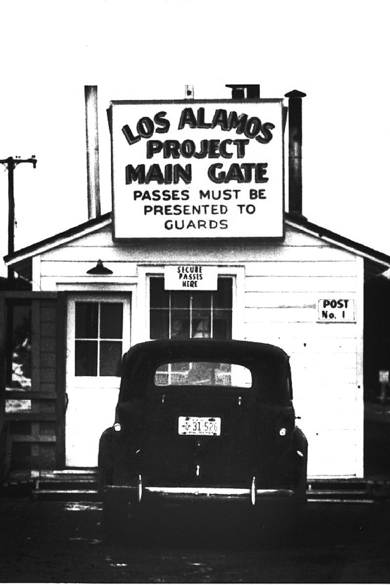 The east gate was the only way in or out of Los Alamos during the Manhattan Project and for some years after. National Park Service photo.
  Today this replica of the Main Gate is a feature of Main Gate Park at the top of the hill on the east side of the city.
  Built in 1948 at the site of a checkpoint, the guard tower stands across the street from Main Gate Park as a chilling reminder of the secrecy of Los Alamos. Today there are still checkpoints where visitors must show an ID and state their business on the main road through the national laboratory’s campus.
  Performing Arts Center/Los Alamos Little Theater. During the Manhattan Project, this building was the laboratory’s east cafeteria which reportedly had the best food in town.
  The “new” Los Alamos National Laboratory campus in 1995. Wikimedia Commons Photo.
The Manhattan Project was successful due to a massive effort that spanned just 27 months from start to finish and included thousands of military and civilian laborers who worked toward a common goal although they were located in three separate sites across the country.
Thank you so much for joining us on our historical tour of Los Alamos! For more national park inspiration, check out these great sites:
Little Rock Central High School National Historic Site
Ulysses S. Grant National Historic Site
Lyndon B. Johnson National Historical Park
Happy, safe travels, y’all!
Mike and Kellye

As always, we strive to be as accurate with our information as possible. If we made a mistake, it was unintentional. (Hey, we’re only human!) Our suggestions are for places that we’ve heard good things about but haven’t visited personally, and our opinions are our own.
©2023
Archives Select Month October 2023 September 2023 August 2023 July 2023 June 2023 May 2023 April 2023 March 2023 February 2023 January 2023 December 2022 November 2022 October 2022 September 2022 August 2022 July 2022 June 2022 May 2022 April 2022 March 2022 February 2022 January 2022 December 2021 November 2021 October 2021 January 2021 May 2020 April 2020 March 2020 February 2020 January 2020 December 2019 November 2019 October 2019 September 2019 August 2019 July 2019 May 2019 April 2019 March 2019 February 2019 January 2019 December 2018 November 2018 October 2018 September 2018