
Oklahoma Archives – One for the Money Two for the Road
Featured 
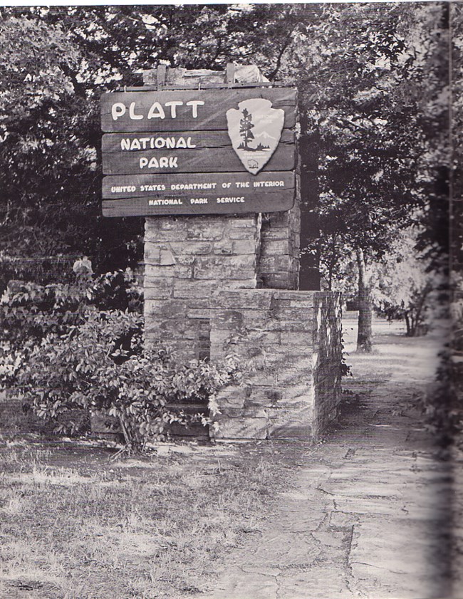
This is the story of a national park that was, then wasn’t. We visited Chickasaw National Recreation Area because we wanted to see what remained of a national park that once was one of the most visited in the United States. In fact, the park attracted visitors to southern Oklahoma before Oklahoma was even an official state!
 Family at the park – probably early 1900s.
Our guess is that most people who visit the park today don’t pay much attention to the park that was. Most of today’s visitors are likely there to enjoy the camping and water sport opportunities that the new park offers. Interestingly, the park has always been about water, but not in the ways most people would think. Enjoy the journey as we explore the historic place that was once Platt National Park.
Birth of a Park
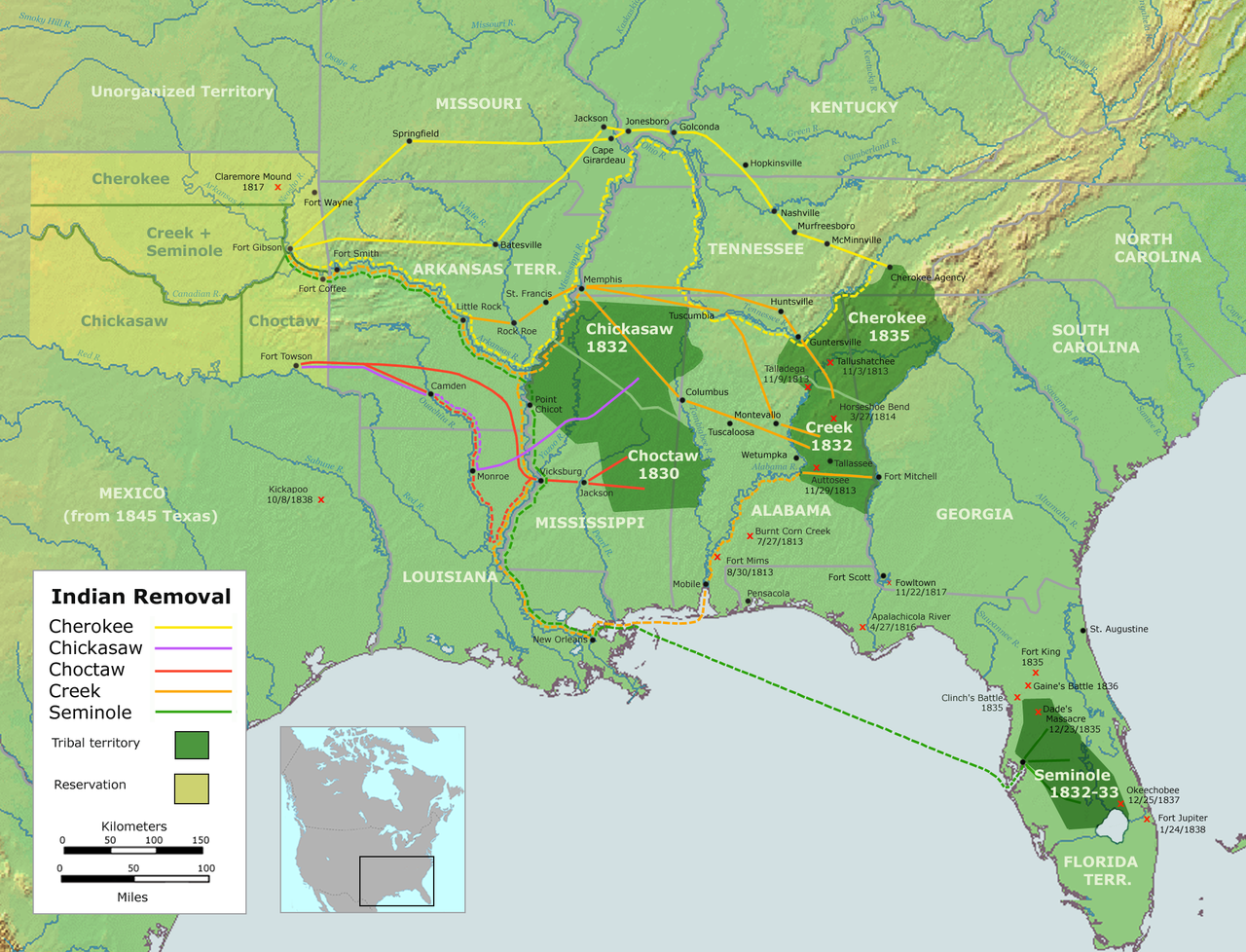
According to the National Park Service: Between the 1830 Indian Removal Act and 1850, the U.S. government used forced treaties and/or U.S. Army action to move about 100,000 American Indians living east of the Mississippi River, westward to Indian Territory in what is now Oklahoma. Among the relocated tribes were the Cherokee, Choctaw, Chickasaw, Creek, and Seminole.
 Trail of Tears map. (Wikipedia)
The trails the tribes followed are collectively called the Trail of Tears. Chickasaw and Choctaw settled on the same land grant in the southern third of Indian Territory but later agreed with the government to split the land between the two nations. Lands acquired by the Chickasaw Nation included the area that would later become Platt National Park.
1924 postcard
Fearing uncontrolled use of their lands’ mineral and freshwater springs, both the Choctaw and Chickasaw Nations sold 32 springs along with 640 acres of land to the Department of the Interior for protection in 1902. The site was initially named Sulphur Springs Reservation, however, four years later the name was changed to Platt National Park.
1939 Guidebook
Platt Historic District
Platt National Park was the seventh U.S. national park and was named after the late Connecticut Senator Orville Platt who had supported legislation to protect the springs located on the land. In 1914, the park, which was then the smallest of all national parks, attracted more visitors than Yellowstone and Yosemite National Parks.
 Fountain at the original entrance to the park built by the Civilian Conservation Corps (CCC) in the 1930s.
  Bromide Pavilion, also built by the CCC in the mid-1930s, was a place for visitors to collect water piped in from Bromide Spring until it quit flowing in the 1970s. Today it is still a beautiful building.
  1930s comfort station. Now modernized, the structure has withstood the test of time.
Pavilion Springs
 Sulphur Springs Pavilion, circa 1902.
Much to the Chickasaw and Choctaw people’s dissatisfaction, visitors flocked to the springs because they believed the mineral waters held healing powers. Resorts such as the one above and others that popped up around the springs brought about the sale of the springs and surrounding lands to the government.
 Renamed Pavilion Springs because of several different pavilions built over them through the years, this photo shows a newer, smaller pavilion. Circa 1904.
  This pavilion was built by the CCC in the 1930s and still covers Pavilion Springs today.
  Pavilion Springs continue to flow. The sign in the background shows the concentrations of minerals in the water.
Travertine Nature Center
Built in 1969, the Travertine Nature Center was the last major improvement project of Platt National Park. The building was designed to reflect the architectural style of renowned American architect Frank Lloyd Wright while keeping the National Park Service Rustic look of the park’s other structures.
The Travertine Nature Center serves as a visitor center in the park, and while it is a newer building it is considered part of the Platt Historic District. Its features include dioramas depicting the park’s wildlife as well as live exhibits of fish and amphibians. Visitors to the center can pick up park brochures, buy a souvenir in the bookstore, and talk with rangers about the park.
 Diorama in the nature center. Foxes, deer, and many other animals can be found in the park.
  We think this guy may be a bluegill which is found in the lakes at the park. Whatever he is, he looks kind of grumpy.
  Travertine Creek flows beneath the nature center – very Frank Lloyd Wright-ish!
And speaking of history, how long has it been since you’ve seen one of these?
 It’s in a little alcove on the outside of the Travertine Nature Center. It doesn’t work anymore, but it was a step back in time to see a pay phone.
Little Niagara
A longtime favorite swimming area for visitors, Little Niagara is a small cascade on Travertine Creek and is just a short walk from the nature center. Improvements at the Little Niagara area, including a dam to create the swimming hole, were also done by the CCC in the 1930s.
 Little Niagara
  People have enjoyed the waters of Travertine Creek and Little Niagara for many years. This photo is probably from the early 1900s.
Lincoln Bridge
Lincoln Bridge, which replaced an old wooden bridge, was the first improvement project of Platt National Park. Amid much fanfare, the bridge was dedicated on February 12, 1909, in honor of President Abraham Lincoln’s 100th birthday and re-dedicated on the same day in 2009 to celebrate its own centennial.
 Approaching Lincoln Bridge
Forrest Townsend, who was the first full-time ranger at Platt National Park, designed Lincoln Bridge. Constructed of limestone, the bridge is 120 feet long and 20 feet wide. Four crenelated (notched) towers form the abutments with steps and a flagpole on each one.
 View of Travertine Creek from Lincoln Bridge
Lincoln Bridge has long been a favorite scenic spot in the park. We found it to be our favorite too.
Trivia: In 2011, as part of the America the Beautiful Quarters Series, the U.S. Mint issued a quarter featuring Chickasaw National Recreation Area and the Lincoln Bridge.
 Lincoln Bridge
In 1976, Platt National Park was abolished by congress and combined with the Arbuckle Recreation Area to form Chickasaw National Recreation Area. We haven’t covered all of the features of the Platt Historic District here, but we feel fortunate to have seen them. Thankfully the National Park Service has done a great job of preserving Platt National Park’s history.
 Little waterfall on Travertine Creek
Where is it?
Chickasaw National Recreation Area is located near the town of Sulfur in southern Oklahoma about 13 miles east of I-35 and the town of Davis. The park’s main visitor center and administration office is located at 901 West 1st Street, Sulfur, Oklahoma. Features of the park include:
- Travertine Nature Center – exhibits, park information, bookstore
- Platt Historic District
- Six campgrounds – some require reservations.
- Veteran’s Lake – hiking, fishing, picnicking
- Lake of the Arbuckles – boating, fishing, camping, fishing, hunting, swimming, picnicking
- Hiking
- Biking
- Bison pasture
- Scenic drives
- Ranger-led programs
- Free admission
Access the park’s website here. 
Thank you so much for joining us!
Want to visit some other amazing national parks? Try these:
Mammoth Cave National Park
Rocky Mountain National Park
Yellowstone National Park
Happy, safe travels, y’all!
Mike and Kellye

As always, we strive to be as accurate with our information as possible. If we made a mistake, it was unintentional. (Hey, we’re only human!) Our suggestions are for places that we’ve heard good things about but haven’t visited personally, and our opinions are our own.
©2023
Featured 
Oklahoma City was the halfway point on our Route 66 adventure through Oklahoma, although we didn’t stop there. We have spent a lot of time in Oklahoma City over the years and decided to skip it for the sake of saving time. Though for anyone who has not visited Oklahoma’s capital, we highly recommend spending a few days checking out everything this wonderful destination has to offer.
 The Gold Dome Building, Route 66, Oklahoma City. Built as a bank in 1958, and designed by renowned architect, Buckminster Fuller, the building is one of the city’s most iconic sights.
Trivia: The world’s first parking meter was installed in downtown Oklahoma City in 1935. Additionally, shopping carts, bread twist ties, and aerosol cans were all invented in Oklahoma.
 Parking meters in downtown Oklahoma City.
Now, back to the route…
Arcadia, Oklahoma
Inside the city limits of Edmond, Oklahoma lies the one square mile town of Arcadia. The tiny town is home to two favorite Route 66 stops: Arcadia Round Barn and Pops.
 Round Barn, Route 66, Arcadia, Oklahoma
Arcadia Round Barn
The unique round barn was built in 1898 by William Odor. The reason he went to the trouble to build a round barn: he thought if it was hit by a tornado, the tornado would go around it instead of through it. By the 1970s the structure had almost collapsed, but volunteers in and around Arcadia came together to restore the old barn. Restoration efforts were completed in 1992 and the round barn has been a beloved Route 66 landmark ever since. Admission to the barn, which also features a gift shop, is free.
Pops
Pops is a convenience store, restaurant, and gas station located just around a curve from the round barn. Its claims to fame are its thousands of bottles of soda pop in hundreds of varieties and its landmark pop bottle sign.
 Pops iconic 66-foot-tall soda bottle, its height a nod to its Route 66 location.
  Colorful sodas on glass shelves line the store’s windows.

Having only been open since 2007, Pops isn’t one of the vintage Route 66 stops, but it has become a very popular one. While there, we opted for a grape soda and a root beer. We don’t usually drink sugary sodas, but when in Rome… Would you try a spaghetti or blue cheese dressing soda?
 Spaghetti? Not for us, thanks.
  Um…no!
Moving on…
Will Rogers
One of the Route 66 nicknames is the Will Rogers Highway. Oklahomans are passionate about the label because Will Rogers was, and probably still is, their favorite native son. Will Rogers was born a citizen of the Cherokee Nation in Indian Territory (about half of Oklahoma before it became a state) in 1879 to parents of mixed heritages. In his lifetime, Rogers wore many hats: cowboy and rodeo star, humorist, world traveler, and actor. He even took a brief turn as Mayor of Hollywood, California. Rogers was best known for his acting career which found him first in vaudeville shows then in Hollywood where he appeared in seventy-one movies. He also wrote a humorous political column that was syndicated in over 4,000 newspapers. Rogers, along with fellow Oklahoman and aviator Wylie Post, died in 1935 when Post’s plane crashed in Alaska Territory.
 One of the many Will Rogers Highway/Route 66 wayside monuments in Oklahoma.
As we made our way along Route 66 in Oklahoma, we found impressive granite “Will Rogers Highway” wayside markers at many of the landmarks. The one above outlines the history of Lucille’s Filling Station near Hydro, Oklahoma.

 Lucille’s, Route 66, Hydro, Oklahoma
Clinton, Oklahoma
Our only stop in Clinton was at the Oklahoma Route 66 Museum which should not be confused with the National Route 66 Museum in Elk City, Oklahoma.

We found this museum to be exceptional as it truly does tell the story of the route through Oklahoma. Carefully curated displays take visitors through the decades of the Route 66 era complete with vintage vehicles, multimedia presentations, and plenty of other sights and sounds. Click on any image below for full views.
 The Great Depression
  Post WWII
  The 60s
  The family station wagon!
  Service stations were such an important part of the history of Route 66
We spent about an hour and a half here, though we could have stayed longer. The Oklahoma Historical Society has done an outstanding job with this museum, and we believe it is a stop that any traveler would enjoy.
Traveling on, we skipped Elk City and Sayer because we had visited those cities on a previous trip.
Erick, Oklahoma
Continuing on the route, we arrived in Erick just after noon on a Saturday. Erick is a neat little town surrounded by ranch land and farms. Sadly, its main street and downtown appeared to be completely deserted when we were there. Erick is the hometown of singer-songwriter, Roger Miller, of “King of the Road” fame. The town once had a museum dedicated to Miller, but it is now closed. We found the mural below featuring Miller on an empty building that may have once been the museum.
 Roger Miller mural on Route 66 aka Roger Miller Blvd., Erick, Oklahoma
Erick’s other claim to fame is that it is also the hometown of singer and actor, Sheb Wooley. Wooley’s hit song “The Purple People Eater” hit number one on the Billboard pop charts in 1958. He also co-starred as Pete Nolan on the TV series “Rawhide”, among other acting roles. We didn’t find a mural of Wooley in Erick, however, we did find the Sandhills Curiosity Shop, another source of inspiration for Disney Pixar’s movie “Cars”.
 Sandhills Curiosity Shop, just off Route 66, Erick, Oklahoma
Trivia: Sheb Wooley recorded the Wilhelm Scream sound effect that has been used in hundreds of movies and TV shows since 1951 and is still being used today. Check it out here: Wilhelm Scream.
Route 66 between Sayre and Erick was a divided highway and one of the nicest parts of the Mother Road that we experienced on our trip. The four-lane road continued to Texola, Oklahoma (a ghost town) and went back to two lanes just past the Texas border.
 Goodbye, Oklahoma. It’s been fun!
Thanks so much for cruising Oklahoma’s Route 66 with us! One more post covering our Mother Road stops in the eastern half of Texas is coming soon.
If you love American road trips as much as we do, check out these other cool places:
Carlsbad Caverns National Park
Antietam National Battlefield
Abilene, Texas Road Trip: Things to Do
Safe travels, y’all. We’ll see you on the road!
Mike & Kellye

As always, we strive to be as accurate with our information as possible. If we made a mistake, it was unintentional. (Hey, we’re only human!) We aren’t paid for our recommendations, and we only recommend our own tried and true vendors and venues. Our suggestions are for places that we’ve heard good things about but haven’t visited personally, and our opinions are our own.
©2023
Featured 
Our recent Route 66 trek began in St. Louis, Missouri and ended in Amarillo, Texas. We drove about 800 miles between the two cities over four days. Traveling Route 66 truly is a kick, but navigating it is sometimes tricky. Although, having to get on and off of the interstate highways when the route ends or backtracking because it’s easy to get lost is just part of the adventure.

Now, on to our first stop…
OK-KS-MO Tri-State Marker
 Three state corner – Kansas, Missouri, and Oklahoma – stand in all three states at once!
Thanks to Google Maps, we had to backtrack to find this off-route site. While Google took us close to it, we kept ending up at a casino and resort in Oklahoma. We finally found it on an almost hidden gravel road next to the resort. Sadly, after all the time and gasoline spent looking for the marker, we found it to be quite unremarkable. We got the cheap thrill of standing in three states at once though, so the stop wasn’t a total failure.
 The original marker was built in 1938, but it is about 50 feet from the actual point.
Tired and hungry, we got on the turnpike, paid our toll, and headed west. We couldn’t find a place to eat, so we got back on Route 66 near Afton, Oklahoma hoping to find food. All we found was barbecue, so we paid another turnpike toll and headed to Catoosa which was our stop for the night. Just when we were both on the verge of becoming hangry, we were gifted with a spectacular Oklahoma sunset. Oh, how nature’s beauty soothes the soul!
 Shot with an iPhone while driving 80 mph down the interstate! Not too bad for a couple of tired and hungry amateurs.
Catoosa, Oklahoma
Catoosa is located on the banks of the Arkansas River and is home to about 7,100 residents. A couple of museums, the Hard Rock Casino, and the Tulsa Port of Catoosa also call the city home. The reason for our stop? The Blue Whale of Catoosa, of course!
 The Blue Whale of Catoosa, Route 66, Catoosa, Oklahoma
In the early 1970s, Hugh Davis built the whale on the edge of his family’s swimming hole as an anniversary gift for his wife Zelta who collected whale figurines. Local residents showed so much interest in the site that the Davis family eventually added a picnic area and opened it to the public. The swimming hole was closed in 1988 due to Hugh’s failing health. He died in 1990. When Zelta died in 2001, the park fell into disrepair, however, local volunteers joined forces to restore the beloved whale. The City of Catoosa purchased the property in 2020, and today it remains a favorite stop for travelers on Route 66.
 Signpost showing other Route 66 icons and their distance from the Blue Whale.
Oklahoma, the eastern part of which was known as Indian Territory
prior to becoming a state, has some of the greatest place names ever. Most of them are from Native American names or words, such as: Quapaw, Catoosa, Pawhuska, Chickasha, and Watonga, just to name a few. Our next stop got its name from a derivative of the Creek tribe’s word tallasi which means “old town.”
Tulsa, Oklahoma
 Windshield shot of Tulsa’s skyline as we pulled into town. We apologize for the bugs.
With only a couple of things we wanted to see in Tulsa, we didn’t spend much time there. Our goal was to see relatives who live just south of the city. Luckily, we were able stop long enough to learn about Cyrus Avery, the “Father of Route 66.”
 Sculpture “East Meets West” – Robert Summers, 2012 – Cyrus Avery Centennial Plaza, Tulsa
This beautiful bronze sculpture depicts Avery stopping his Ford on the 11th Street Bridge as the automobile startles two horses pulling a wagon carrying oil barrels.
U.S. Highway 66 Association
In 1927, while serving as a member of a board appointed to create the Federal Highway System, Cyrus Avery successfully advocated for the establishment of the U.S. Highway 66 Association. The association was instrumental in ensuring that the road was paved in its entirety, a major undertaking which was completed in 1938. Furthermore, the association continued to promote Route 66 tourism for more than forty years. In 1970 the association changed its name to Main Street of America Association. However, with new interstates bypassing the old highway, or replacing sections of it completely, the association dissolved in 1976. Click here for a short National Park Service article about the origins of Route 66.
 The 11th Street Bridge, Tulsa, Oklahoma. Note the art deco railings.
One picture, three eras. The photo above shows the current Route 66 Bridge (left) crossing the Arkansas River, the original Route 66 Bridge (middle) also known as the Cyrus Avery Memorial Bridge, and Interstate 44 (right). Cyrus Avery Memorial Bridge is included on the National Register of Historic Places.
 Pedestrian bridge over Route 66, Tulsa
  University Club Tower, Tulsa, Oklahoma
We found the 32-story University Club Tower apartment building to be intriguing with its retro vibe and location overlooking the Arkansas River. Completed in 1966, the tower is supposedly the first major building in the U.S. to be designed using a computer.
Moving on Down the Road
 Mainer Ford in Bristow, Oklahoma. The building, while delightfully deco, was actually built in 2010 and features a very cool retro neon sign. We applaud Mainer Ford for keeping the spirit of Route 66 alive.
  Here’s the cool retro sign for the Skyliner Motel in Stroud, Oklahoma – an oldie but goodie – and the motel is still in business!
Trivia: Indian Territory, which was comprised of most of the eastern half of Oklahoma, almost became the state of Sequoyah. Tribespeople living in Indian Territory held a constitutional convention and overwhelmingly voted for Sequoyah’s statehood. However, due to party politics on the national level, the plan failed. The people of Indian Territory were forced to see their lands merge with Oklahoma Territory to become the 46th state as Oklahoma officially joined the union on November 16, 1907.
 Route 66, The Mother Road, America’s Main Street, Will Rogers Highway – they’re all names for America’s U.S. Highway 66.
Chandler, Oklahoma
Chandler, Oklahoma helps to preserve its Mother Road heritage with the Chandler Route 66 Interpretive Center. The center is housed in the Chandler Armory building which was constructed in 1937 and is on the National Register of Historic Places. While the center is part museum, it also has a gallery that features videos and artwork depicting the history of the route. We enjoyed watching the videos from the unique seating the center has installed for the comfort of its guests. It even has vinyl beds to lounge on while watching the videos. Needless to say, it is a very laid back, relaxing experience, especially for weary travelers.
 Chandler Route 66 Interpretive Center
  We found this painting of Chandler’s Phillips 66 Cottage Gas Station in the interpretive center. The actual building is pictured below.
  The colorful Phillips 66 Cottage Gas Station in Chandler, Oklahoma was built in 1932 and continued to function as a gas station until 1992.
Warwick, Oklahoma
Eight miles west of Chandler is Warwick, Oklahoma, home of the Seaba Station Motorcycle Museum. We spent over an hour in the museum where we saw some unique motorcycles and learned the history of the building as well.
 Seaba Station
The building was constructed for use as a gas station in 1921 by John Seaba and his wife, Alice. Later John turned the building into a machine and engine rebuilding shop but sold the business in 1951. In 1995, the building was sold again, refurbished, and reopened as an antiques store. The current owners purchased the property in 2007 and have restored the front to look like the original gas station. The addition of the motorcycle museum was completed in 2010.
 Inside the motorcycle museum
  This bike is outfitted with a Johnson Motor Wheel which turned an ordinary bicycle into a motorcycle and cost about $80.00. Circa 1920.
Trivia: Oklahoma’s official state meal includes barbecued pork, chicken fried steak, sausages and gravy, fried okra, grits and squash. The state bean is the black-eyed pea, and the state fruit is the strawberry. Pecan pie is the official state dessert.
This is where we close the post but stay tuned for more of our Route 66 adventure coming soon. Thank you so much for joining us on the eastern half of Route 66 Oklahoma.
If you like American road trips, we think you will enjoy these posts:
Route 66 – Missouri
Kancamagus Highway, New Hampshire
Death Valley National Park
Travel safely, and we will see you on the road!
Mike and Kellye

As always, we strive to be as accurate with our information as possible. If we made a mistake, it was unintentional. (Hey, we’re only human!) We aren’t paid for our recommendations, and we only recommend our own tried and true vendors and venues. Our suggestions are for places that we’ve heard good things about but haven’t visited personally, and our opinions are our own.
©2023

Washita Battlefield National Historic Site lies along the banks of the Washita River in southwestern Oklahoma. The site is also part of the Black Kettle National Grassland which is managed by the National Forest Service. Twelve miles north of the park is the Black Kettle Recreation Area featuring:
- Tent camping sites (no reservations/no fee)
- Hiking and interpretive trails
- Picnic Area
- Lake with boat ramp
- Fishing
- Wildlife viewing
Cheyenne, Oklahoma is the nearest town and is located 23 miles north of I-40 and Sayre, Oklahoma via US Highway 283.
For additional information, here is a link to the park’s website: Washita Battlefield
 The park’s pretty landscape
We visited this park in early March, and while the temperatures were in the mid-60s, so were the winds. At least it felt that way. The gusts were so high, we couldn’t hold the camera still. We had to keep reminding ourselves that we were in Oklahoma where the “wind comes sweepin’ down the plain”. Despite the blustery gusts, we thoroughly enjoyed our visit surrounded by the peaceful setting and gorgeous landscape. Our photos don’t do justice to the park’s golden and red tinged grasses, russet bluffs, and gently rolling hills.
 This battlefield photo is a victim of the wind, but we included it because it reminded us of an old painting of the pristine landscape
Significance of the Site
Southern Cheyenne leader Chief Black Kettle and approximately 250 of his tribespeople were encamped for the winter in a village here on the banks of the Washita River. More than 5,000 other Cheyenne, Arapaho and Kiowa were also peacefully encamped in villages farther down the river. Following hostile attacks by bands of Cheyenne on white settlers in Kansas, renowned Civil War general, Philip Sheridan, ordered a retaliatory attack, and his (likely unwarranted) target was Black Kettle’s village. On November 27, 1868, Lieutenant Colonel George A. Custer led 800 soldiers of the 7th Cavalry in the surprise early morning raid, killing scores of village’s occupants including women and children. The assault would become known as the Battle of the Washita.
 This monument, located near the encampment site, tells the story of the Battle of the Washita. Offerings of remembrance and prayer line the top of the monument.
Casualties of the Battle
Upon hearing of the attack, warriors from the larger villages downstream had rushed to aid Black Kettle and his people. Their help was probably too little and too late, and sadly, both Black Kettle and his wife, Medicine Woman Later were killed in the battle. The death toll remains sketchy, but approximately 103 Cheyenne and 22 US Army personnel perished, along with the Cheyenne’s herd of ponies. Survivors of the battle included fifty-three Cheyenne women and children who were captured and taken to Fort Hays in Kansas. Custer’s soldiers were instructed to destroy all evidence of the village, therefore all fifty-one of the Cheyenne’s lodges were burned and most of their ponies were slaughtered. When all was said and done, nothing remained of the village except the bones of 800 ponies, which were finally removed from the site in 1935.
 George Armstrong Custer – photo courtesy of the Library of Congress
Custer’s Destiny
In an ironic twist of fate, Lieutenant Colonel George A. Custer met his demise almost eight years later in June 1876 during the Battle of the Little Bighorn in Montana. The US Army (7th Cavalry) suffered defeat against a band of thousands of Native American warriors composed mostly of Northern Cheyenne and Lakota Sioux. Little Bighorn is considered the most significant battle of the Great Sioux War, which was a series of conflicts and unkept agreements between Native American tribes and the US government. Perhaps most famously, the Battle of the Little Bighorn is remembered as Custer’s Last Stand.
 Identifying exactly where the lodges stood is difficult because everything was burned. However, some archaeological evidence points to this area along the southern bank of the Washita.
Why Visit This National Park Site?
Washita Battlefield tells just one story of the many adversities the native peoples suffered, especially as our country expanded westward into their homelands. Though we tend to turn our sympathies more toward Black Kettle and his people, the park does an excellent job of explaining what happened from each side’s point of view. Besides, we’re never too old or too young to learn, and where better to learn something than at a free national park. Plan to spend at least an hour in the visitor center because there is a film and a museum that are interesting as well as educational. From the visitor center, drive about a quarter mile to the village site and then walk the 1.5-mile interpretive trail to learn more about what took place on that fateful day in 1868.
 Looks like another painting. Isn’t it pretty? Not a telephone pole, billboard, cell tower, or wind turbine in sight.
Thank you so much for joining us on our quick trip to Washita Battlefield National Historic Site.
Looking for more history? Check out these historic sites:
Fort Union National Monument
Eisenhower National Historic Site
Marsh-Billings-Rockefeller National Historic Site
Travel safe, travel smart, and we will see you down the road.
Mike and Kellye

As always, we strive to be as accurate with our information as possible. If we made a mistake, it was unintentional. (Hey, we’re only human!) We only recommend our own tried and true vendors and venues. Our suggestions are for places that we’ve heard good things about but haven’t visited personally, and our opinions are our own.
©2022
Archives Select Month November 2023 October 2023 September 2023 August 2023 July 2023 June 2023 May 2023 April 2023 March 2023 February 2023 January 2023 December 2022 November 2022 October 2022 September 2022 August 2022 July 2022 June 2022 May 2022 April 2022 March 2022 February 2022 January 2022 December 2021 November 2021 October 2021 January 2021 May 2020 April 2020 March 2020 February 2020 January 2020 December 2019 November 2019 October 2019 September 2019 August 2019 July 2019 May 2019 April 2019 March 2019 January 2019 December 2018 November 2018 October 2018 September 2018