
UNESCO World Heritage Site Archives – One for the Money Two for the Road
Featured 
Chaco Canyon was a busy place 1,000 years ago. Early great houses (large public buildings) began being built around 800 AD, and construction continued for about 300 years. Today the ruins of the Chacoan great houses stand as a testament to their builders’ culture, brilliant architectural and astrological knowledge, and remarkable ability to thrive in the harsh conditions of the desert southwest. Enjoy your visit. 
Where is it?
Chaco Canyon lies in the Four Corners region of the US in northwestern New Mexico. (Four Corners is where the corners of the states of New Mexico, Arizona, Utah, and Colorado meet.) A town called Nageezi is the closest map dot to the park, but it doesn’t offer much more than a turn off for the road to the canyon, which involves another 24-mile trek, and part of the road is very bumpy gravel. But getting there is half the fun, right?
 On the (smooth) road to Chaco Canyon.
Besides being a national park unit, Chaco Culture National Historical Park is also a UNESCO World Heritage Site and a designated International Dark Sky Park. Features of the park include:
- Visitor center, museum, park film
- Bookstore/gift shop
- Nine-mile-long Canyon Loop Drive – open to motor vehicles and bicycles.
- Three additional bike trails.
- Four backcountry trails – permit required.
- Gallo Campground, featuring 32 individual and two group sites which can be reserved through www.recreation.gov. RV, tent, and car camping is available with some restrictions and no hook ups.
- Periodic night sky events, and the park also features an observatory.
- Periodic ranger led tours or talks.
- Seasonal hours apply.
- Admission fee applies.
Access the park’s website here.
 Chaco Canyon Visitor Center
Many Roads Led to Chaco Canyon
Chaco Canyon was a regional center for trade, and an elaborate road system covering hundreds of miles connected the area’s great houses. The map below shows the great houses and the roads.  Chaco Culture National Historical Park, formerly Chaco Canyon National Monument, protects the 16 great houses in and around the canyon. The park’s great houses are the best preserved prehistoric architectural structures in North America. Additionally, archaeological and anthropological studies of the site have resulted in the discovery of over 1.5 million artifacts, most of which are in the care of the University of New Mexico in Albuquerque.
 A glimpse inside the park’s museum.
The new Chaco Canyon Visitor Center and museum opened in 2017 after years of planning and construction. Artifacts from the park’s collection as well as some borrowed from other museums were to be displayed in the park’s museum. Unfortunately, the heating and air conditioning system does not provide the proper climate controls needed to preserve the artifacts. Now, several years later with no resolution to the climate control issues in sight, empty display cases line the walls of the museum.
 Some of the display cases feature reproduction pottery such as the jar shown above.
Despite the fact that the museum didn’t have original artifacts, it did provide us with a lot of interesting information about the canyon, its inhabitants, and the great houses.
The Great Houses
Builders of the great houses quarried stone and carried timber from many miles away. They also constructed dams, waterways, and stairways. Chaco Canyon’s great houses are sacred to many Native American tribes.
Hungo Pavi was occupied from AD 1000 – 1250s and remains unexcavated.
 Hungo Pavi
Chetro Ketl is the second largest great house in Chaco Canyon and was occupied from AD 950 – 1250s. With 400 rooms, it covers 5.5 acres (2.3 hectares) which actually makes it the largest in terms of surface area.
 Chetro Ketl practically blends into its surroundings.
  Chetro Ketl’s back wall.
  Petroglyphs on the mesa wall between Chetro Ketl and its closest neighbor Pueblo Bonito.
Pueblo Del Arroyo was occupied from AD 1075 – 1250s. Unlike other Chacoan great houses, Pueblo Del Arroyo does not have a great kiva (communal meeting place or possible ritual site). Perhaps its people shared Pueblo Bonito’s great kivas, as the two great houses sit just a few hundred yards apart.
 Pueblo Del Arroyo
  Archaeologists who excavated Pueblo Del Arroyo in the mid 1920s uncovered only about half of the great house.
Pueblo Bonito
The largest of all great houses, was occupied from AD 850 – 1250s and was the first Chacoan great house to be excavated.
 Pueblo Bonito as seen from the trail.
Archaeologists believe that Pueblo Bonito was the convergence point of the roads leading to Chaco Canyon. The four story, D-shaped structure featured about 800 rooms, 32 kivas, and four great kivas. Its number of occupants remains debatable due to the lack of trash piles and burial sites. Some theorize that the huge great house was used primarily as a ritual site, thus the four great kivas.

In 1941, 30,000 tons of rock slid off of the mesa’s face and destroyed about 30 of the pueblo’s rooms. The Chacoan builders of the great house knew a rockslide was possible and had built supporting masonry walls just in case. Remarkably, Threatening Rock as it was called, held stable for centuries before it finally gave way.
 View of the pueblo and the rockslide.
  It is hard to tell how big the pueblo is from ground level.
For size and scale purposes, the aerial photo below shows the great house and the rockslide debris. Credit for the photo goes to Bob Adams of Albuquerque, New Mexico via Wikipedia.
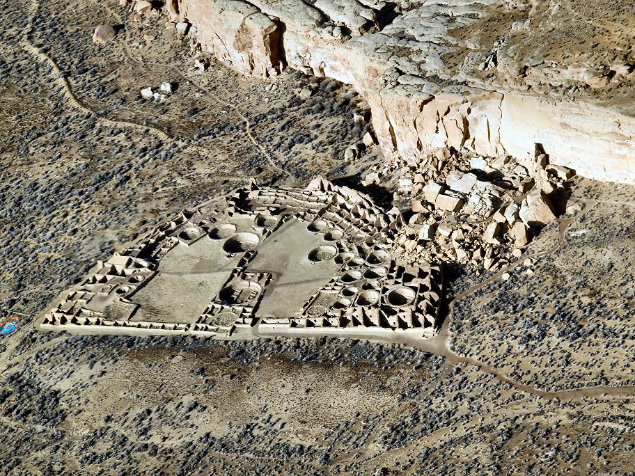 Aerial view of Pueblo Bonito.
More Canyon Highlights
Casa Rinconada Community was occupied from AD 1075 – 1250s and is considered a village rather than a great house. The village features the largest great kiva in the canyon.
 Casa Rinconada Community’s great kiva.
From wayside information: Unlike the monumental Chacoan great houses, the villages along this trail are more modest. Yet both the great houses and the villages were built and occupied during the same period. Hundreds of these small villages and communities have been discovered clustered around Chacoan great houses. The role of the great houses isn’t clear. Perhaps they served a central purpose: ceremonial, economic, and administrative, and the small village communities supported those efforts.
 Ruins of the Casa Rinconada Community.
Una Vida is another of Chaco Canyon’s great houses and was occupied from AD 850 – 1250s. Basically untouched, Una Vida has had little excavation.
 Ruins at Una Vida
According to archaeologists, Una Vida was two to three stories tall and had 100 ground floor rooms and kivas. Additional rooms surrounded the plaza. Interestingly, a jewelry workshop was found at Una Vida along with pottery from Mesa Verde which is now Mesa Verde National Park.
 Petroglyph panel at Una Vida.
Desert sand and vegetation preserve most of Una Vida and its great kiva, so it looks much like it did when it was discovered in 1849. Una Vida is reached via a 1-mile out and back trail that starts at the visitor center.
Wetherill Cemetery
A lonely patch of sandy scrubland is the final resting place of Richard Wetherill, his wife, Marietta, and several others.
 Wetherill Cemetery
Richard Wetherill was a Colorado rancher, but he had a passion for ancient puebloan culture and was an amateur archaeologist. He is credited with coining the word Anasazi to describe the ancient ones who occupied the ancestral pueblo dwellings of the southwestern US and is also credited with rediscovering and excavating some of the dwellings at what is now Mesa Verde National Park.
 Richard Wetherill
Wetherill established a homestead in Chaco Canyon where he assisted in excavating Pueblo Bonito under the auspices of the American Museum of Natural History. He ran a trading post in the canyon until his death. Click here to learn more about Mr. Wetherill and his mysterious murder.
Fajada Butte

Rising approximately 440 feet (135 meters) from the canyon floor, Fajada Butte is the predominant natural landmark in Chaco Canyon. It is also sacred to the Navajo, Hopi, and Pueblo peoples, and it is home to the most significant petroglyph in the canyon: the Sun Dagger.
According to the park: Atop Fajada Butte Chacoan skywatchers commemorated the movement of the sun and the seasons. Sunlight passed between three boulder slabs onto a spiral petroglyph to mark the sun’s position on summer solstice, winter solstice, and the equinoxes.
In recent years, scientists have noticed a change in the light pattern on the spiral due to slipping of the boulder slabs. They suspect that the slipping could be from human-caused erosion to the base of the rocks, and as a result access to Fajada Butte is prohibited.
See a photo of the Sun Dagger here.
Wildflowers
We were fortunate to visit Chaco Canyon when many wildflowers were blooming. We hope that we have identified them correctly. Click on any image in the gallery below to view as a slideshow.
 Wild Rubharb
  Narrowleaf Beardtongue
  Desert Plume
  Scarlet Globemallow
  King Cup Cactus
  Evening Primrose
  Wild Rubharb
  Easter Daisy
  Fleabane
  Fleabane
  Notch-leaved Phacelia
  Mormon Tea
Thank you so much for joining us on our Chaco Canyon road trip! We appreciate you more than we can express. We’re closing the post with one of the friends we made on our visit to the park.
 Common blotch-sided lizard
Want to see more in New Mexico? Check out these great destinations:
New Mexico’s Salinas Pueblo Missions
Pecos National Historical Park
Albuquerque to Taos Road Trip: Things to Do
Safe travels, y’all!
Mike and Kellye

As always, we strive to be as accurate with our information as possible. If we made a mistake, it was unintentional. (Hey, we’re only human!) Our opinions are our own.
©2023
Featured 
We covered Yellowstone National Park in a seven-part series several years ago. This is an enhanced and updated single post highlighting the sections of the magnificent park which is also UNESCO World Heritage Site.

Getting There
Our journey began by flying to Salt Lake City, Utah and renting a car for the road trip. The distance between Salt Lake City and West Yellowstone, Montana, which was our home base, is 320 miles/4.5 hours via I-15. We chose to break up the trip by spending our first night in Idaho Falls, Idaho.
⇒From Salt Lake City, take I-15 north toward Ogden, Utah. Continue north toward Pocatello, Idaho. Stay on I-15 to Idaho Falls.
Drive time between Salt Lake City and Idaho Falls is 3 hours through gorgeous scenery.
 Falls on the Snake River, Idaho Falls, Idaho
⇒From Idaho Falls, take US Highway 20 north toward Rexburg, Idaho. Continue north to West Yellowstone, Montana, which is the west entrance into the park. Drive time between Idaho Falls and West Yellowstone: 1.75 hours.
⇒Must-do stops in West Yellowstone include the Museum of the Yellowstone and the Grizzly and Wolf Discovery Center
Destination – Yellowstone National Park
The scenic Grand Loop Road through Yellowstone is laid out in a figure eight as shown on the map below. The highest speed limit we saw was 45 miles per hour, but that doesn’t mean much. When there are animal sightings, traffic stops. Bison jams are common, and visitors are at a standstill until the big beasts decide to move out of the way. Heavy traffic also slows travel, especially in the summer months.

Madison Area
 The Madison River meanders lazily past Mount Haynes
Trivia: the Madison is one of the three rivers that converge near Three Forks, Montana to form the headwaters of the Missouri River. The other two rivers are the Gallatin and the Jefferson.
 Gibbon Falls
  Steamy water and brilliant colors from the runoff of Blood Geyser in the Artists’ Paint Pots area of the park
Other points of interest in the Madison area of the park include:
- Terrace Springs
- Fountain Paint Pots
- Midway Geyser Basin
- Fairy Falls
- Firehole River
- Madison Information Station
Norris Area
The Norris Geyser Basin is the hottest area of Yellowstone National Park, in volcanic terms that is. Visitors will find geysers, hot springs, mud pots, steam vents, pools, and lakes at Norris. Steamboat Geyser, the largest geyser in the world, is also located here, though its eruptions are irregular and unpredictable. Hiking and walking trails are the best way to see everything this area has to offer.
 Porcelain Basin, Norris Geyser Basin
  Green and yellow thermophiles (hot water loving bacteria) create a spilled paint effect
Other points of interest at the Norris area of the park include:
- Norris Geyser Basin Museum
- Norris Bookstore
- Norris Campground
- Museum of the National Park Ranger
Canyon Village Area
The canyon village area is home to the Upper and Lower Falls of the Yellowstone River and the Grand Canyon of the Yellowstone. These are some of the most popular sights in the park.
 Grand Canyon of the Yellowstone
  Lower Falls
Trivia: Lower Falls is 308 feet tall, which is twice as high as Niagara Falls, and it is the highest waterfall in the park.
Points of interest in the Canyon Village Area include:
- Overlooks on North Rim Drive and South Rim Drive
- Uncle Tom’s Trail – 328 stairs to a Lower Falls viewpoint
- Canyon Lodge and restaurant
- Campground
Driving south from Canyon Village toward Lake Village and West Thumb Geyser Basin, visitors will pass through Hayden Valley. This area of the park is a great place to see wildlife and early mornings and evenings are best for sightings.
 The Yellowstone River meanders through Hayden Valley
Just past Hayden Valley is Mud Volcano and Dragon’s Mouth Spring. The area is super interesting and super sulphur-y! Take it from us, the intriguing sights will make you forget all about the smell.
 Mud Volcano’s pit of boiling mud of is difficult to see in this shot because of the steam
Some of the sights on the Mud Volcano Trail include Mud Cauldron, Mud Geyser, Sizzling Basin, Cooking Hillside, Black Dragon’s Cauldron, Grizzly Fumarole, and Sour Lake. All are aptly named, but don’t be afraid of the smells. This where Yellowstone shows off some of its best volcanic features.
 Dragon’s Mouth Spring. This spring not only spews steam and emits boiling water, but it also roars!
Six miles south of Mud Volcano is the Lake Village area which includes the Fishing Bridge, Visitor Center, Lake Yellowstone Hotel, and marina.
West Thumb Geyser Basin Area
The West Thumb Geyser Basin and Grant Village areas of the park are located approximately 28 miles/30 minutes southwest of the Lake Village area. Located on the banks of Yellowstone Lake, West Thumb, which is a small caldera, has some of the most colorful pool features of the park.
 Lots of shades of blue, and not a cloud in the sky – Yellowstone Lake
West Thumb features hiking/walking trails (boardwalk), a bookstore and information station, as well as a campground. Grant Village includes a hotel and visitor center.
 Bluebell Pool
  Black Pool
  Abyss Pool
Upper Geyser Basin Area and Old Faithful
This area of the park sits halfway between West Thumb and Madison and is the most popular section of the park.
 Old Faithful Geyser
While it is not the biggest or most frequently erupting geyser in Yellowstone National Park, Old Faithful is certainly the most popular. Visitors flock to the grandstand viewing area to watch it erupt, which it does about every 90 minutes.
 Built in 1904, the Old Faithful Inn is a National Historic Landmark
Things to do in the Upper Geyser Basin:
- Hiking/walking (boardwalk) trails
- Old Faithful Visitor Education Center
- Gift Shop
- Eat – there are five restaurants and/or grills in the area
- Biscuit Basin
- Black Sand Basin
- Morning Glory Pool
 The Upper Geyser Basin has over 150 hydrothermal features and approximately half of the geysers in the world!
Trivia: the chalky white substance around the geysers in Yellowstone is called geyserite.
Midway Geyser Basin Area
Grand Prismatic Spring, which is the third-largest hot spring in the world, is the star of the Midway Geyser Basin.
 Nature’s art. Up close view of the thermophiles – Grand Prismatic Spring
  Excelsior Geyser
Excelsior Geyser once spewed hot water hundreds of feet into the air, but it hasn’t erupted since the mid-1980s. Today 4,000 gallons of boiling water per minute pour from its crater into the Firehole River.
 Turquoise Pool can also be found in the Midway Geyser Basin
We are including Fountain Paint Pots as a sub-area of the park because we thought the area had some interesting sights, especially the geysers. The area is located between Midway Geyser Basin and Madison.
 Silex Spring
  Clepsydra Geyser erupts almost constantly
Trivia: a clepsydra is a water clock, and the name in the Greek language means water thief.
Mammoth Hot Springs Area
The springs in this area have created a series of travertine terraces. A boardwalk trail takes visitors through this amazing wonderland of minerals, water, and thermophiles.
 Minerva Terrace
  Palette Spring
  Rustic Falls can be seen from an overlook near Mammoth Hot Springs
Other highlights in the Mammoth Hot Springs area include:
- Historic Fort Yellowstone
- Albright Visitor Center – museum
- Mammoth Hot Springs Hotel
- Gardiner, Montana
- Heritage and Research Center (in Gardiner)
- Historic Roosevelt Arch at the North entrance to the park
Roosevelt-Tower Area
Note: As of 2022, parts of the north and northeast sections and entrances to the park may be closed due to flood damage. Check the website for information about road and trail closures.
The northern part of the park has rolling hills, meadows, and wildlife – what a thrill!

 Bison jam!
Trivia: Yellowstone’s bison were once on the verge of extinction due to unenforced hunting in the early years of the park. The current genetically pure (haven’t been bred with cattle) herd, which now numbers in the thousands, are descendants of the original twenty-four that were diligently preserved and carefully bred by the park.
 Calcite Springs and the Yellowstone River
  Columnar basalt decorates the cliffs overlooking the Yellowstone River.
  Tower Fall, 132 feet tall
The Roosevelt area of the park features Roosevelt Lodge and Cabins, a campground, and restaurant. A general store with fast food and a gas station can be found at Tower. The Tower Fall trailhead is next to the store.
Lamar Area
Unfortunately, we were unable to visit this section of the park. The Lamar Valley is reportedly one of the best viewing areas for wolves and other wildlife at Yellowstone. Located in the Northeast corner of the park near the Cooke City entrance, the scenic drive features mountains, the Lamar River, and trailheads for several trails. The drive from the northeast entrance to the Roosevelt-Tower area is 28 miles/1 hour.

Thank you for staying with us through this long post. Yellowstone is the one U.S. National Park that everyone should get to see at least once in their lifetime. And it’s the only one we want to revisit because once wasn’t enough for us! We are going to close the post with an up-close shot of one of the formations at Palette Spring.
 Travertine icicles drip from a ledge while tiny water droplets create dangling strings of pearls. The icy-looking landscape is enhanced by the cascading colors of the thermophiles.
Looking for more national park adventures? Click on these:
Death Valley National Park
Black Canyon of the Gunnison National Park
Bryce Canyon National Park
Travel safe, travel smart, and we will see you down the road!
Mike and Kellye

As always, we strive to be as accurate with our information as possible. If we made a mistake, it was unintentional. (Hey, we’re only human!) We aren’t paid for our recommendations, and we only recommend our own tried and true products, vendors, and venues. Our suggestions are for places that we’ve heard good things about but haven’t visited personally, and our opinions are our own. Photo copyright infringement is not intended. Our written content and photos are copyrighted and may not be published without our permission.
©2022
Featured 

Getting There
Carlsbad Caverns is: 150 miles from El Paso, Texas, 200 miles from Lubbock, Texas, and 300 miles from Albuquerque, New Mexico
El Paso is the closest city with a major airport so our road trip will start from there.
⇒From El Paso, take US Highway 62/180 east toward Carlsbad, New Mexico. Distance between El Paso and Carlsbad Caverns: 150 miles/2.25 hours.
Travel tip: fill up with gas, use the restroom, and grab a few drinks and snacks before leaving El Paso. Services are very minimal along this desert highway. Watch for the salt flats and beautiful mountain peaks of Guadalupe Mountains National Park along the way.
 Guadalupe Mountains National Park – view from the highway at Guadalupe Pass
Carlsbad Caverns Visitor Information
- Timed entry reservations are now required to enter the park. The free passes can be obtained by calling 877-444-6777 or online at recreation.gov. Timed passes are only for reserving a time to enter the park and cannot be obtained at the park. Entry fees are paid upon arrival at the park’s visitor center.
- Basic Entrance Fee: $15.00 per person for a 3-day pass. Kids 15 and under are admitted free, and baby strollers are not allowed in the cavern.
- Parts of the Big Room Trail are wheelchair accessible.

- Ranger guided tours to other sections of the cave (or other caves) may be available for additional fees. Advance reservations and proper footwear are required for guided tours.
- Hours vary depending on the season. Check the website for information.
- A cafeteria is available in the visitor center, and a snack bar is located in the cavern near the elevators and restrooms.
- Hotels and restaurants are available in the city of Carlsbad, New Mexico.
- RV/tent camping is available in White’s City, the city of Carlsbad, and on Bureau of Land Management (BLM) lands near the park. Backcountry camping requires a permit. Check the website for additional information.
- When to go? Anytime.
- Website Link: Carlsbad Caverns
Learn Before You Go

 Do you know the difference between stalagmites and stalactites? A stalagmite grows on a cave’s floor, so watch where you’re walking, or you might (mite) trip over it. Stalactites grow from a cave’s ceiling, so if they don’t hang on tight (tite) they could fall. A park ranger at Carlsbad Caverns told us this years ago, and we haven’t forgotten his wise words!
Travel tip: the temperature in the cave is a constant 56 degrees, so a light jacket is recommended, along with sturdy, closed toe walking shoes with non-slip soles.
 The Dolls Theater is a perfect example of columns and soda straws
Carlsbad Caverns
Prepare to descend seventy-five stories beneath the earth into a dark and magical place like no other in the world. Stalagmites, stalactites, domes, totems, mirror-like pools, and even chandeliers make for breathtaking sights (as well as exceptional photo ops) on your journey through Carlsbad Caverns. Walk into the caverns via the natural entrance if you are up for the challenge or take the speedy elevator to the entrance of the Big Room. The Big Room Trail is a little over a mile long, and it is definitely worth every step. Plan to spend at least two hours in the cavern.
 Huge drippy “fountains” of calcite grow from the floor of the cave
  Interesting drapery formations seem to cascade out of the cavern’s walls
  This gorgeous dome started out as a tiny stalagmite on the cavern’s floor
The Park is More Than a Cave
Most people visit Carlsbad Caverns to see the caves, but the park has much more to offer such as:
- An amphitheater from which to watch up to 500,000 bats come out at night during the months of May through October
- Walnut Canyon Scenic Drive – 9.5 miles on an unpaved road
- Ranger led night sky programs
- Picnic areas
- Hiking trails
- Shopping, exhibits, and a nature walk at the visitor center
 A stalagmite “Christmas tree” inside the cavern’s wall is framed by calcite popcorn and soda straw “icicles”
Carlsbad Caverns National Park and neighboring Guadalupe Mountains National Park are part of an ancient reef that was created by an inland sea about 250 million years ago. Approximately 300 known caves have been found in the areas surrounding the parks with 119 of them in Carlsbad Caverns National Park alone. The parks lie in the Chihuahuan Desert which covers 250,000 miles and reaches into parts of Texas, New Mexico, and Arizona, although ninety percent of the desert lies in north-central Mexico.
 Chihuahuan Desert heat and haze as far as the eye can see
Discovery of the Caverns
Indigenous people are said to have known about the caves long before modern exploration, however, cowboy Jim White is credited with the discovery of the caverns. In 1898, sixteen-year-old White was searching for stray cows when he saw smoke rising up from the ground. Upon approach he quickly realized the smoke was actually thousands of bats emerging from a large hole. Jim fashioned a rickety ladder from fence wire and sticks, and a few days later he climbed down into the hole carrying nothing but a lantern and an axe. How terrifying it must have been to take those first steps into the unknown! Jim continued to explore and map the caverns throughout the years and even assisted with building the improvements to make the cave accessible to visitors. White also served as Chief Ranger of Carlsbad Cave National Monument from 1926-1929.
 Jim White’s ladder can still be seen in the cavern today
Creation and Sustainability of the Park
- President Calvin Coolidge signed a proclamation designating Carlsbad Cave National Monument in October of 1923.
- Congress formally established Carlsbad Caverns National Park in May of 1930.
- Citing its caves’ natural beauty, unique features and formations, and ongoing geologic processes, UNESCO proclaimed the park a World Heritage Site in 1995.
The park averages almost half a million visitors per year which may be detrimental to the cave. Visitors are instructed not to touch the formations because the build-up of bodily oils causes them to die. Carbon dioxide from our breath can even damage the delicate ecosystem of the caverns. During our visit we saw park volunteers using small paintbrushes to painstakingly remove lint, yes lint, left behind from visitors’ clothing and skin. Lint builds up in nooks and crannies along the trail and also attracts unwanted insects, so the park has it removed – about 44 pounds of it per year in the Big Room alone!
 These draperies remind us of bacon
  Rock of Ages
  Dagger-like stalactites and soda straws dangle from the Big Room’s ceilings.
Lechuguilla
Carlsbad Caverns National Park is also home to another one of the deepest and most beautiful caves in the world – Lechuguilla. The cave’s name (pronounced letch-uh-ghee-a) comes from a type of agave plant that grows only in the Chihuahuan Desert. Bat guano was mined from the cave’s entrance through the early 1900s, but after mining operations ceased the area was basically forgotten. A Colorado exploration company, suspecting another large cave lay hidden beneath the park, got permission to begin digging in 1984. In 1986, they broke through to discover a virtual fairyland. So far, explorers have found huge draperies, delicate chandeliers, cave pearls, and colorful pools, though their explorations continue. Lechuguilla is not open to the public and is only accessible to scientific researchers and authorized exploration teams. Click here for a National Park Service photo gallery: Lechuguilla Cave Gallery. Click here for a YouTube video: Lechuguilla Cave Video.
 The lechuguilla plant, also called shin dagger, looks like it could cause some pain! The plant flowers once in its life then dies.
Nearby Attractions:
- Living Desert Zoo and Gardens State Park – located in the city of Carlsbad
- Brantley Lake State Park. Water sports, RV and tent camping – located 20 miles/30 minutes north of the city of Carlsbad via US Highway 285
- Lake Carlsbad Beach Park. Water sports, playground, swimming, fishing, and miles of walker-friendly sidewalks – located at 708 Park Drive, Carlsbad, New Mexico.
- Guadalupe Mountains National Park – 56 miles/1 hour south of the city of Carlsbad, and 25 miles/30 minutes south of Carlsbad Caverns National Park via National Park Highway.
- Sitting Bull Falls – 57 miles/1 hour southwest of Carlsbad in the Lincoln National Forest via US Highway 285 and State Highway 137.
Also check out our Quick Stop post that features Carlsbad’s famous flume. The “It’s a Fact, Jack” section is interesting too. Here’s the link: Quick Stop – The Flume
 Chinese Theater
Want to lean about other national parks sites? Click on these exciting destinations:
10 Amazing Things to See and Do at Big Bend National Park
Gettysburg National Military Park
Fort McHenry National Monument and Historic Shrine
Grand Canyon National Park
 Last look: draperies, like clusters of jellyfish, appear to spill from a hole in the ceiling of the cave. It’s hard to believe that slow dripping water created these amazing formations!
We sincerely hope our road trip to Carlsbad Caverns National Park inspires you to grab your camera, hop in the car, and head that way.
Mike and Kellye

As always, we strive to be as accurate with our information as possible. If we made a mistake, it was unintentional. (Hey, we’re only human!) Our opinions are our own.
©2022
Featured 
Our visit to the Alamo and San Antonio Missions National Historical Park took place on Palm Sunday. What a wonderful day to see the historic mission churches and celebrate their history! In addition to the Alamo, there are four missions along the banks of the San Antonio River which compose San Antonio Missions National Historical Park. Each of the mission churches are still active parishes today. As proud Texans, we hope you will enjoy our tour of the only UNESCO World Heritage Site in our state.
Our first stop was the Alamo.
The Alamo
 Mision San Antonio de Valero. The Alamo (which means cottonwood in Spanish) is located in downtown San Antonio, Texas. Contrary to what most believe, the entire compound, what is left of it, is the mission. The building pictured above is the mission church which is universally recognized as the Alamo. Built by Spanish missionaries, the church and mission date to 1718. The Battle of the Alamo took place here in 1836. Although the Mexican army won the battle, it was significant in the events leading to Texas gaining independence from Mexico. The mission was added to the National Register of Historic Places in 1966. The Alamo is included as part of the San Antonio Missions UNESCO World Heritage Site, though it is not part of the national historical park. The Alamo is owned and managed by the State of Texas.
Travel tip: no photography of any kind is allowed inside the church.
 Beautiful tree on the mission grounds. We had to wonder what this tree has witnessed in all of its years here. Just under the bottom branch in the center-right of the shot is the mission’s water well.
  This building, which is located on the mission grounds, houses “The Alamo: A Story Bigger Than Texas” exhibit featuring artifacts from the Alamo and the Phil Collins Texana collections. While there is no fee to enter the church building or grounds, there is a fee to enter this building, and advance tickets are recommended.
Free timed tickets are required to enter the mission church and can be obtained from the kiosk in Alamo Plaza or online at: https://www.thealamo.org/visit/calendar/alamo-free-timed-entry
Travel tip: we got our exhibit tickets and timed entry tickets for the church online and included them as part of our itinerary to save time upon arrival.
 The Alamo Cenotaph (south side)
The Alamo Cenotaph is a monument commemorating the Battle of the Alamo and honors those who fought in the battle. Its actual name is Spirit of Sacrifice. The stunning sculpture by Texas artist Pompeo Coppini is sixty feet tall, forty feet long, twelve feet wide, and stands adjacent to the mission at Alamo Plaza. On the east and west sides, the bas relief sculptures depict the leaders of the battle. Names of some of the Texans (then known as Texians) who fought there are engraved into the granite near the base. The monument was dedicated in September of 1940.
 West side
  East side
  North side
And speaking of historic buildings, we are including some interesting facts about the Emily Morgan Hotel which interests many who visit the Alamo.
 The Emily Morgan is a registered Texas Historic Landmark and was added to the National Register of Historic Places in 1977
Opened in 1924 as a medical arts building with doctors offices and hospital facilities, the building served its original purpose until 1976 when it was updated to house modern office spaces. In 1984 the site became the Emily Morgan Hotel. In 2012, after undergoing major renovations, it became a Hilton Doubletree Hotel but kept the name Emily Morgan. An unusual feature of the exquisite building is its gargoyles depicting different medical ailments. The building sits just north of Alamo plaza so its grounds, which were once part of the mission, saw the deaths of hundreds of men. The hotel is said to be one the most haunted places in San Antonio.
Ever heard the song “Yellow Rose of Texas”? Legend has it that Emily (West) Morgan was the Yellow Rose of Texas. Read all about it here: https://officialalamo.medium.com/who-was-the-yellow-rose-of-texas-750c95617241

San Antonio Missions
Our second stop was Mission Concepcion which sits in a residential neighborhood a few miles south of San Antonio’s downtown area.
 Full name: Nuestra Senora de la Purisima Concepcion
Mission Concepcion, which dates to 1755, is the only unrestored stone church in America. As with all of the Spanish missions, its purpose was to convert native people to Christianity and integrate them into communities where they could be taught trades and farming in order to become self-sufficient. The mission was originally established in east Texas, however the Franciscan priests, who wanted to bring the native people into Spanish culture, chose to move away from the French influences of what is now Louisiana. This site of Mission Concepcion was chosen in 1731, and it took about 15 years to complete the buildings.
 Mission Concepcion. Note the water well in the left-center foreground. Each of the missions have a similar well.
The mission church and convento (building complex where missionaries, visitors, some residents, and the parish priest resided on the mission grounds) boast of their 250-year-old frescoes which are beautifully preserved today. The outside of the church was also once painted with bright colors, but those have been erased over time. Interestingly, the stone for this mission was quarried on its own grounds.  While the Mission Concepcion church was constructed in the Spanish Colonial style, some Moorish features were also incorporated, such as this pretty archway and stairwell outside of the church. This nook was so unexpected, we had to wonder if it was original to the mission.

Because services were being conducted while we were visiting Mission Concepcion, we were unable to enter the church.
Our third stop was Mission San Jose. The national park visitor center is located here and provides helpful information about all of the missions.
 Full name: Mission San Jose y San Miguel de Aguayo
  Founded in 1720, the San Jose Mission and Church were completed in 1782. We arrived just as Palm Sunday services were ending.
  Luckily, we were able to get a picture of the beautiful sanctuary, though the church was crowded with parishioners and other tourists. It was the only one of the mission churches that we were able to photograph inside.
 Mission San Jose was our favorite of the four missions. It is also the most restored, with the majority of the restorations having been completed in the 1930s by the Civilian Conservation Corps (CCC) which gave unemployed young men work relief during the Great Depression. Approximately 80% of the church is original.
 Convento and water well. The white edges above the stone arches are where roofs once were.
  Housing for the native residents of the mission. Each home has two small rooms and a tiny fireplace. Eighty-four of these “apartments” encompass the mission grounds.
San Jose Mission was touted as the Queen of the Missions. While it was not constructed as a fort, the mission was said to be as secure as any fort of the day, thereby protecting its residents against attacks by hostile outsiders.
 Granary completed in 1755 and restored in the1930s
Our fourth stop was Mission San Juan, which was a little disappointing at first glance because we thought the church was new. Once we began our trek around the mission grounds, we found out we were wrong!
 Full Name: Mission San Juan Capistrano
Similar to Mission Concepcion, Mission San Juan’s humble beginnings were in east Texas in 1716. The original mission, Mission San Jose de los Nazonis, was established to serve Nozonis Indians in the area, but the mission failed, so it was reestablished in its current location in 1731 and renamed Mission San Juan Capistrano. The mission suffered misfortune in its new location too. Epidemic diseases such as smallpox and measles killed many of the natives. Attacks by hostile bands of Apache and Comanche Indians also plagued the mission. These adversities caused some of the inhabitants to leave mission life behind and return to their nomadic lifestyle.
 Mission San Juan Church dates to 1772 and is the mission’s second church. The stone walls were covered in plaster in 1984, and other preservation measures were completed in 2012.
Construction of a third church was begun in 1775 but was never completed because of the decline in the population of the mission.
 Unfinished church dates to 1775 with some restoration in the mid 20th century
The native people who built and lived at this mission were farmers of food and fiber. They also made tools and cloth which, along with the crops, enabled trade that helped sustain the community. By 1762, about 203 people were residing at the mission. Remains of several farm tracts and an irrigation system can be found near the mission, as well as a dam which is not open to the public. The national park operates a demonstration farm for visitors today, using the same irrigation system (acequia) and growing the same types of crops.
 Convento, restored in the 1960s


Our fifth and final stop was Mission Espada which was our second favorite of the four San Antonio missions.
 Full name: San Francisco de la Espada
Mission Espada is the oldest of the Texas missions, having been founded in 1690. As with other missions it was established first in east Texas but was reestablished in its current location near the banks of the San Antonio River in 1731.
 Mission Espada Church, completed in 1756
The residents of Mission Espada made bricks, some of which can still be seen in the mission’s structures. Residents of Espada also made tiles, wove cloth, made tools, and raised crops and livestock.
 This arched entryway to the mission shows the brickwork
  Ruins of some of the original mission buildings
 Espada also had an aqueduct which still exists today and diverts water from the San Antonio River to the mission and its farmland. A portion of the aqueduct is pictured above as it crosses Piedras Creek, and below is the acequia (irrigation canal). This acequia is still used by people who live near Espada.
For more information about San Antonio Missions National Historical Park, click here: https://www.nps.gov/saan/index.htm
That’s going to be all for this trip. We are thrilled that you stopped by our site, and we hope you return again for another great road trip. We would love to hear about your road trips so feel free to leave us a comment below. Until the next trip… Travel safe, travel smart, and we will see you down the road.
Mike and Kellye
As always, we strive to be as accurate with our information as possible. If we made a mistake, it was unintentional. (Hey, we’re only human!) We aren’t paid for our recommendations, and we only recommend our own tried and true vendors and venues. Our suggestions are for places that we’ve heard good things about but haven’t visited personally, and our opinions are our own.
©2022
Featured 
 Intricate details on the historic Trinity Church, Boston.
If you have followed our posts, you’ve probably noticed that we love churches – especially historic ones. Today we’re sharing a few of our favorites, and we hope you love them too. Enjoy!
 Another detail of the Trinity Church in Boston – love the gargoyles!
  Trinity Church, Boston. Built 1872 – 1877.
  Mission Church, Pecos National Historical Park, New Mexico. Built in 1717.
  Old North Church, Boston. Built 1723.
  Quechee Church, Quechee, Vermont. Built in 1873.
  The Chapel of the Holy Cross, Sedona, Arizona. Built 1954 – 1956.
  Ruins of the San Jeronimo Mission Church at Taos Pueblo. Dates to approximately 1706.
  Saint Patrick’s Cathedral, Harrisburg, Pennsylvania. Built 1907.
  The Cathedral of Saint Helena, Helena, Montana. Built 1908.
  Cathedral Basilica of Saint Francis of Assisi, Santa Fe, New Mexico. Built 1869 – 1887.
  The First Church of Christ, Scientist (also known as The Mother Church), Boston. Built 1894 – 1906 with later additions.
  Chapel at Mount Saint Mary’s Cemetery, Maryland. Cemetery established around 1808.
  San Jose de Gracia in Las Trampas, New Mexico, built in 1760.
  Grace Methodist Church, Harrisburg, Pennsylvania. Built 1873 – 1878.
Thank you for visiting our site! We hope you will come back again for more great road trip destinations, Quick Stops, WWWTWs, and some tips and tricks. Become a follower so you never miss a post – just hit that SUBSCRIBE button on the right-side of the page. We will not share your information with anyone!
Happy hump day, everyone!
Mike and Kellye

As always, we strive to be as accurate with our information as possible. If we made a mistake, it was unintentional. (Hey, we’re only human!) We aren’t paid for our recommendations, and we only recommend our own tried and true vendors and venues. Our suggestions are for places that we’ve heard good things about but haven’t visited personally, and our opinions are our own.
©2022
Featured 
 Grand Tetons, Grand Teton National Park
Today we’re running away to the mountains! Since our goal is to visit as many national parks as we can, most of our shots are of beautiful park mountains. There are a few that are not in parks because they were too pretty to leave out. Enjoy!
 Casa Grande in the rain – Chisos Mountains, Big Bend National Park
  Big Sky Country
  Bryce Canyon National Park
  Guadalupe Mountains National Park
  Agathla Peak, Arizona
  Zion National Park
  Idaho Beauty
  Yellowstone National Park
  Death Valley National Park
  Rocky Mountain National Park
Today’s featured image at the top of the page was taken at Yellowstone National Park.
Thanks so much for joining us on our mountain getaway. We hope you will return to our site again for more sights, scenery, trips, tricks, and tips. Be sure to sign up to be an e-mail follower so you never miss a post, and follow us on Facebook, Pinterest, and Twitter. Tell your friends! We want to be friends with them, too.
Happy hump day, everybody!

As always, we strive to be as accurate with our information as possible. If we made a mistake, it was unintentional. (Hey, we’re only human!) We aren’t paid for our recommendations, and we only recommend our own tried and true vendors and venues. Our suggestions are for places that we’ve heard good things about but haven’t visited personally, and our opinions are our own.
©2022
Featured 
The home of Thomas Jefferson, Monticello sits atop a hill on some of the 5,000 acres of land that he inherited from his father. Begun in 1768, it took Jefferson forty years to complete the house. This was partially due to his love of architecture and partially due to the fact that family members moved in and needed space. Our tour guide told us that Mr. Jefferson’s sister moved in with her eleven children during the years in which he was supposed to be enjoying retirement.
 Thomas Jefferson’s bed is tucked into an alcove between the actual bedroom and his office.
About 60 percent of the current contents of the home did belong to Jefferson, though some items have been lost, are in other museums, or in the hands of private collectors. We saw several of his inventions, including a two-sided clock that can be seen inside the house and above the door on the porch, a dumbwaiter hidden in the side of the dining room fireplace that goes to the wine cellar, and a contraption which held a second pen and copied everything as he wrote.
The property, along with the University of Virginia, is a UNESCO World Heritage Site. The university, which is just a few miles from Monticello, was established by Jefferson who also designed the original buildings. Construction began on the most famous building, The Rotunda, in 1822, and was completed just after Jefferson’s death in 1826.
 Sundial and view from the north terrace
  Another view from the north terrace: The Rotunda at the University of Virginia. Jefferson wanted to be able to see the university from his home. Now it is visible through a hole in the trees.
  The Rotunda, which was designed to be a library, at the University of Virginia up close with the symbols of the ultra secretive Seven Society and a statue of Thomas Jefferson
  The Rotunda from the lawn. The Palladian architecture looks very similar to Monticello, but was modeled after the Pantheon in Rome.
Monticello was also home to more than 100 enslaved laborers, including Jefferson’s half sister-in-law, Sally Hemings. It is now known that Jefferson fathered at least six of Hemings children, four of whom lived to adulthood. The story of Sally Hemings is fascinating, though little is known about her – not even what she looked like or where she is buried. What is known about her is detailed on the Monticello website here: https://www.monticello.org/sallyhemings/. There are also Amazon Video and Netflix documentaries about her and her ancestors for those who want to learn more. Notably, James Hemings, Sally’s older brother, was Jefferson’s chef at Monticello. James went to Paris with Jefferson while he was serving as Minister to France. James was trained in French cooking there and became a master chef. Sally arrived in Paris two years later while serving as Jefferson’s daughter’s companion and maid. Interestingly, slavery had been outlawed by then in France so legally James and Sally were free while they lived there.
 Another view of the house looking south
Mulberry Row, a community in itself, is where the laborers lived and worked at Monticello. Here the excavated remains of homes and several shops, such as ones where carpentry and blacksmithing among other crafts and trades took place, can be seen today. The lush flower and vegetable gardens that were once tended by enslaved people are still grown at Monticello along Mulberry Row. For more information on Mulberry Row click here: https://www.monticello.org/slavery/landscape-of-slavery-mulberry-row-at-monticello/.
Jefferson was penniless when he died on July 4, 1826. His heirs were tasked with selling off acreage, possessions (sadly this included slaves who were said to have represented 90 percent of his property) and eventually the grand house to pay the debts. Monticello passed through several owners before being purchased by the Thomas Jefferson Foundation in 1923.
Past Mulberry Row is a path that leads to Monticello’s cemetery where Thomas and Martha Jefferson are buried along with many members of their family. Though no known African-Americans are buried in the family cemetery at Monticello, archaeologists discovered an unmarked Jefferson-era slave cemetery in 2001. This discovery was important because it is known that 400 – 600 enslaved people worked and lived at Monticello, and until the cemetery was found nobody knew where they had been buried.
 Thomas Jefferson’s grave
We could go on for days about what we learned at Monticello, however, we have to end somewhere. In closing, we leave you with these final tidbits:
*Monticello had up to five bathrooms (privies), or air closets as Jefferson referred to them on his blueprints for the home. Historians know that the house did not have flush toilets, but not much else is known about the workings of them.
*Though Jefferson was representing the government as the Minister to France, all expenses involved with living and entertaining there were out of his own pocket.
*The Hemings family were inherited by Thomas and Martha Jefferson upon the death of Mrs. Jefferson’s (and Sally Hemings’) father, John Wayles.
*Sally Hemings quarters were discovered and excavated in 2017 then restored and opened to the public in 2018.
*Jefferson was only thirty-three-years-old when he was asked to write the Declaration of Independence. It only took seventeen days for him to compose the document and two days for the Second Continental Congress to make changes and declare independence on July 4, 1776. We never knew that any government got things done that quickly!
Finally, we highly recommend clicking on https://www.monticello.org/ to learn about the third President of the United States and his beloved home.
Thank you for hanging with us through this long post. We hope you will join us again soon for another great road trip. Until next time…
Travel safe, travel smart, and we will see you down the road!

As always, we strive to be as accurate with our information as possible. If we made a mistake, it was unintentional. (Hey, we’re only human!) We aren’t paid for our recommendations, and we only recommend our own tried and true vendors and venues. Our suggestions are for places that we’ve heard good things about but haven’t visited personally, and our opinions are our own.
©2021
Archives Select Month September 2023 August 2023 July 2023 June 2023 May 2023 April 2023 March 2023 February 2023 January 2023 December 2022 November 2022 October 2022 September 2022 August 2022 July 2022 June 2022 May 2022 April 2022 March 2022 February 2022 January 2022 December 2021 November 2021 October 2021 January 2021 May 2020 April 2020 March 2020 February 2020 January 2020 December 2019 November 2019 October 2019 September 2019 August 2019 July 2019 May 2019 April 2019 March 2019 February 2019 January 2019 December 2018 November 2018 October 2018 September 2018